MARITIME AFFAIRS SAFETY FACILITIES
The International Maritime Buoyage System by the International Association of Marine Aids to Navigation and Lighthouse Authorities (IALA) is classified into region A and region B. Korea, Japan, Taiwan, the Philippines, and North?South America follow the system for region B while other countries follow region A.
Types, meanings, color, shape, and signal type for IALA maritime buoy methods (region B)
| Type of aid | Meaning of aid | Color | Summit shape | Color by signal | Signal type | |||
|---|---|---|---|---|---|---|---|---|
| Color | Shape | Color | Signal method | |||||
| Flank aid | Port side aid | 1. The aid is located on the far left of the route. 2. There are navigable waters to the right side of the aid. 3. There are obstacles such as rocks, reefs, sunken vessels etc. to the left of the aid. |
Green | Green | 1 Cylindrical structure |
Light buoy:  Buoy:  Light beacon:  Beacon sign: 
|
Green | 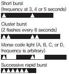 |
| Starboard side aid | 1. The aid is located on the far right of the route. 2. There are navigable waters to the left side of the aid. 3. There are obstacles such as rocks, reefs, sunken vessels etc. to the right of the aid. |
Red | Red | 1 Conical structure |
Light buoy:  Buoy:  Light beacon:  Beacon sign: 
|
Red | ||
| Port side priority channel aid | There is a priority route to the left of the aid. | 1 green horizontal line on red background | Red | 1 Conical structure |
Light buoy:  Buoy:  Light beacon:  Beacon sign: 
|
Red | 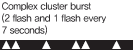 |
|
| Starboard side priority channel aid | There is a priority route to the right of the aid. | 1 red horizontal line on green background | Green | 1 Cylindrical structure |
Light buoy:  Buoy:  Light beacon:  Beacon sign: 
|
Green | ||
| Bearing aid | North cardinal aid | 1. There are navigable waters to the north of the aid. 2. There are obstacles such as rocks, reefs, sunken vessels etc. to the south of the aid. 3. Entry/exit·curve point·intersection or junction for the route is to the north of the aid. |
Upper section black, lower section yellow | Black | 2 Conical bell-type structures (tip of the bell facing upwards) |
Light buoy:  Buoy:  Light beacon:  Beacon sign: 
|
White | 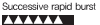 |
| East cardinal aid | 1. There are navigable waters to the east of the aid. 2. There are obstacles such as rocks, reefs, sunken vessels etc. to the west of the aid. 3. Entry/exit·curve point·intersection or junction for the route is to the east of the aid. |
1 yellow horizontal line on black background | Black | 2 Conical bell-type structures (tip of the bell facing downwards) |
Light buoy:  Buoy:  Light beacon:  Beacon sign: 
|
White | 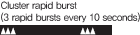 |
|
| South cardinal aid | 1. There are navigable waters to the south of the aid. 2. There are obstacles such as rocks, reefs, sunken vessels etc. to the north of the aid. 3. Entry/exit·curve point·intersection or junction for the route is to the south of the aid. |
Upper section yellow, lower section black | Black | 2 Conical bell-type structures (tip of the bell facing downwards) |
Light buoy:  Buoy:  Light beacon:  Beacon sign: 
|
White |  |
|
| West cardinal aid | 1. There are navigable waters to the west of the aid. 2. There are obstacles such as rocks, reefs, sunken vessels etc. to the east of the aid. 3. Entry/exit·curve point·intersection or junction for the route is to the west of the aid. |
1 black horizontal line on yellow background | Black | 2 Conical bell-type structures (tip of the bell facing upwards) |
Light buoy:  Buoy:  Light beacon:  Beacon sign: 
|
White |  |
|
| Isolated danger aid | There are isolated obstacles such as rocks, reefs, sunken vessels etc. at or near the aid. | 1 red horizontal line on black background | Black | 2 Conical bell structures |
Light buoy:  Buoy:  Light beacon:  Beacon sign: 
|
White |  |
|
| Safe waters aid | 1. There are navigable waters near the aid. 2. The aid is located at the center of navigable waters. |
1 red/white vertical line | Red | 1 Circular structure |
Light buoy:  Buoy: 
|
White |  |
|
| Special purpose aid | 1. The waters surrounding the aid are located near the border of special zones such as construction sites. 2. There are special purpose facilities located near or at the aid. |
Yellow | Yellow | 1 X-type structure |
Light buoy:  Buoy:  Light beacon:  Beacon sign: 
|
Yellow | 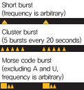 |
|
| New hazardous material aid | Indicates the location of new hazardous obstacles such as sunken vessels when they occur. | Blue/yellow vertical lines | Yellow | + type |  |
Blueㆍyellow arc light |
 |
|
| Light vessel | Generally placed in critical waters with heavy traffic to serve as landfall markers. | Red | - | - |  |
Select appropriately | - | |
 |
||||||||
Coastal Passenger Ferry
| Route | Ship Name | Total Tonnage | Passenger Cap. (Person) |
Passenger Transportation during 2013(Person) |
|---|---|---|---|---|
| Gunsan-Piando | Okdo Ferry | 169 | 253 | 145,708 |
| Jindalrae | 52 | 90 | ||
| Gunsan-Maldo | Jangja Ferry | 124 | 166 | 25,091 |
| Gunsan-Keyado | Keya Ferry | 104 | 92 | 19,131 |
| Gunsan-Eochungdo | New Eochung Ferry | 121 | 140 | 22,958 |
| Yido-Kyokpo | Daewon Car Ferry | 350 | 322 | 202,973 |
| Pajanggeum Car Ferry | 350 | 322 | ||
| Total Sum | 1,270 | 1,385 | 415,861 |