VTS Area
  • Harbor area and sea surface formulated by connecting the following points successively
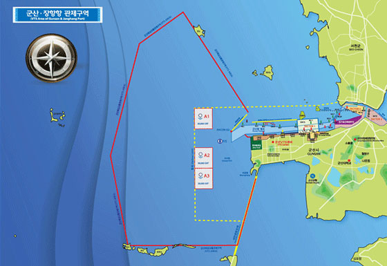
    VTS Area
    • (1) 36° 00' 14" N 126° 31' 00" E
    • (2) 36° 07' 30" N 126° 24' 00" E
    • (3) 36° 04' 43" N 126° 20' 00" E
    • (4) 35° 57' 00" N 126° 16' 30" E
    • (5) 35° 51' 30" N 126° 18' 45" E
    • (6) 35° 51' 30" N 126° 30' 00" E
    • (7) 35° 56' 00" N 126° 31' 56" E
SITE MAP
  1. INTRODUCTION
    1. Greeting
    2. History of Office
    3. Organization
    4. Location Map
  2. PORT INFORMATION
    1. Gunsan Port Overview
    2. Gunsan Port pier status
    3. Exclusive piers
    4. Janghang Port
    5. Inner port
    6. Saemangeum Shinhang(new port) construction
    7. User information and port entry/exit
    8. Other information
  3. SAFETY & SECURITY
    1. General
    2. VTS Area
    3. Reporting, Pilotage and Communication
    4. VTS Website
  4. MARITIME AFFAIRS SAFETY FACILITIES
    1. Origin of lighthouses
    2. History of lighthouses in Korea
    3. Timeline for navigational beacons
    4. Navigational beacons overview
    5. Navigational beacon management office
    6. Navigational Aids Patrol Ships
    7. International maritime buoyage system
  5. MARINE ENVIROMENT
    1. What are public waters?
    2. Marine enviromental remediation activities
    3. Sea area utilization consultation
    4. Management of uninhabited islands
  6. PASSENGER TRANSPORT
    1. Passenger Transport