MARITIME AFFAIRS SAFETY FACILITIES
Visual aids to navigation : using lamps or fire to indicate location at night
-
Basic Requirements
- Aids should be seen within the required range
- Aids should be clearly separated from other lights with certain features to allow for seafarers or observers to identify them without difficulty
- Blinking intervals should remain constant and accurate, and easy to identify by seafarers
- Lanterns and light sources should have high efficiency and credibility as far as possible
- Aids should comply with proper safety standards in order to meet usages requirements and purposes of aids with regard to geographical navigatio
-
Types of Visual Aids to Navigation
| Type |
Description |
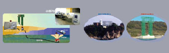
| Lighthouse |
 Manned
Lighthouse
|
A tower containing a powerful flashing lamp that is built on the coast to guide ships, indicate location of a harbor or gates of a port. It is also used for ships to determine their own location or where land falls. |
 Unmanned
Lighthouse
|
| Light Pole |

|
With the same purpose as a lighthouse, it has the simpler structure of a pole with floating lights |
| Light beacon |

|
It is a structure located on shoals and reefs to indicate the existence of dangerous obstacles or routes near the navigating routes. If it has light fixtures, it is a light beacon, if not, it is a beacon |
| Illuminating light |

|
A tower with a projector reflecting high intensity light on reefs or the top of breakwaters to inform vessels of the existence of the obstacles |
| Leading Lights |

|
A two-light structure with light fixtures. A front light is installed at a lower height while a rear light is installed at a higher height. It is built on land, in a line extending from the navigating route to indicate difficult channels, harbors or port gates with a narrow entrance |
| Direction Lights |

|
A structure with projecting lights of three different colors - green, white, and red - built on a site on land in a line extending from the navigating route to indicate difficult channels, harbors or port gates with a narrow entrance. The vessels may navigate through the safe zone lit in white. |
| Light Buoy |

|
Light buoys are floating at sea to indicate reefs, shoals and limits of the channel. If it has light fixtures, it is a lighted buoy, if not, it is an unlighted buoy |
Shape Aids to Navigation : indicating the location with shapes or colors during daytime
-
Basic Requirements
- This system employs a simple arrangement of shapes and colors to mark a location during daytime
-
Types of Shape Aids to Navigation
Sound Aids to Navigation : indicating a location by generating sounds when visibility is
restricted by fog, snow, rain, etc.
-
Basic Requirements
- Sound aids to navigation inform their location to vessels with sounds generated by sound waves.
Machines that generate sound waves for this purpose are fog signals
- Fog signals are built in areas or harbors of often restricted visibility by fog, snow, sunset, heavy rain or haze. Under these conditions, they are operated day and night. They have a relatively short range, as they are operated by sound. Moreover, the range and direction of sound vary according to weather or sea conditions
-
Types of Shape Aids to Navigation
Radio Navigation : Using it as indicators for navigation by taking advantage of the
various characteristics of radio waves
-
Basic Requirements
- Every indicator with the features of radio waves such as straight, constant velocity or reflexibility for vessels or airplanes is called radio navigation or radio-beacon. As it makes use of radio waves, it has the advantages of availability under any conditions and range across a broad area.
-
Types of Shape Aids to Navigation
Special Purpose Aids to Navigation : Sending various navigation information including
vessel traffic or tidal current directions with radio waves or shapes to navigational
vessels during day or night in narrow straits or waterways.
-
- VTS : Designed to guide vessels for safe navigation by installing radar and CCTVs in waters like port entrances or channels, or narrow channels
- Tidal Current Signal Station : A large screen signal system indicating strength and direction of tidal current to navigational vessels
sailing in strong waters like harbor entrances or channels, or narrow channels
- Weather signal box : Designed to give necessary information like special weather reports to navigational vessels
- Radar Beacon : A radar response unit to show the location of a transmitting station with Morse-code on a vessel's radar screen
IT based maritime traffic system
-
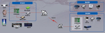 Remote monitoring system
-
 Maritime weather signal system
-
 Current signal system
-
 A to N AIS/navigational aid automatic identification system


